Anna Point Marina
13721 Anna Point Ln, Mineral, VA 23117
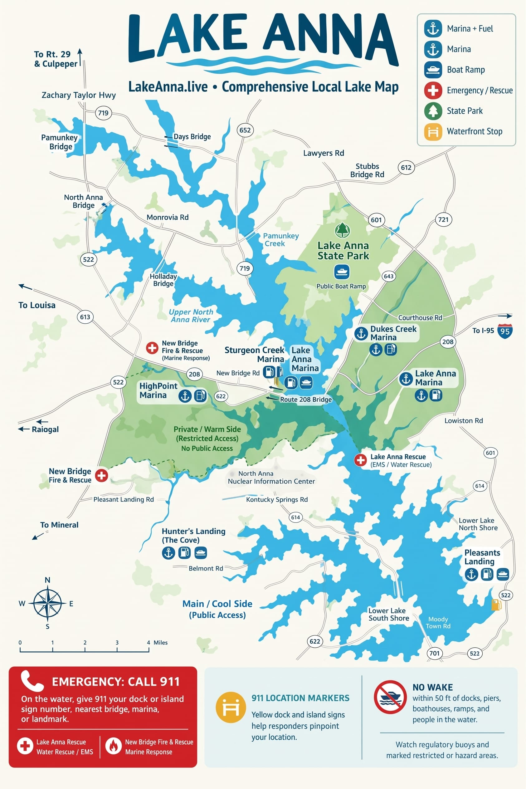
Complete on-water and roadside navigation guide for Lake Anna, Virginia. Pan and zoom our high-resolution nautical chart, calculate boating vs. driving distances, check marina gas dock hours, review 911 yellow dock safety markers, and navigate the Cool vs. Warm sides.

Marinas offering non-ethanol marine fuel (89 & 93 octane), concrete boat ramps, slip rentals, and certified mechanics.
Current hours, ethanol-free marine gas, boat ramps, and services for Lake Anna's commercial marinas.
Boater Tip: Always run 89+ octane ethanol-free fuel in marine engines on Lake Anna to prevent phase separation and carburetor gumming. HighPoint Marina provides 24/7 automated credit card pumps at the water dock.
Launch fees, ramp lanes, trailer parking, and fuel details across Cool Side and Warm Side locations.
13721 Anna Point Ln, Mineral, VA 23117
4634 Courthouse Rd, Mineral, VA 23117
5107 Courthouse Rd, Spotsylvania, VA 22551
349 Pleasant Landing Rd, Bumpass, VA 23024
3838 Breaknock Rd, Bumpass, VA 23024
6800 Lawyers Rd, Spotsylvania, VA 22551
7149 Zachary Taylor Hwy, Mineral, VA 23117
5420 Elk Creek Rd, Mineral, VA 23117
6320 Belmont Rd, Mineral, VA 23117
200 Boardwalk Wy, Mineral, VA 23117
208 Lake Front Dr, Mineral, VA 23117
200 Lake Front Dr, Mineral, VA 23117
349 Pleasant Landing Rd, Bumpass, VA 23024
13924 Anna Point Ln, Mineral, VA 23117
208 Lake Front Dr, Mineral, VA 23117
Lake Anna is a dual-basin reservoir created in 1972 by Dominion Energy. The lake is divided into two distinct bodies of water separated by earthen dikes. Knowing the critical boundary differences prevents costly trespassing citations and navigation mistakes.
The Main Lake comprises the vast majority of Lake Anna, stretching over 17 miles along the North Anna River and Pamunkey Creek. It is fully accessible to the general public and serves as the epicenter for tourism, commercial boating, and championship angling tournaments.
Officially designated as the Waste Heat Treatment Facility (WHTF), this series of three interconnected cooling lagoons circulates water to absorb thermal energy from the North Anna Power Station before returning it to the main lake.
No. The Cool Side and Warm Side are physically isolated by three large earthen dikes (Dikes 1, 2, and 3). There are no canals, locks, or lift stations for boats. Attempting to portage a boat over the dikes or cross the security boundaries of North Anna Power Station is strictly forbidden under federal and state maritime law.
In an on-water emergency, seconds matter along Lake Anna’s 200+ miles of shoreline. Follow the unified 911 Yellow Marker system and locate emergency rescue response teams.
Lake Anna spans three distinct counties (Louisa, Spotsylvania, and Orange) across more than 200 miles of winding shoreline. Identifying your exact position from the water can be confusing, especially at night or in bad weather.
The bright yellow location signs with bold black codes (e.g., L-14 or S-08) are mapped with precise GPS coordinates in all county 911 computer-aided dispatch systems.
Scan the shoreline for the nearest private dock or bridge with a bright yellow sign.
Call 911 and state clearly: “I have an emergency on Lake Anna at Marker [Code].”
Anchor or maintain your position near that marker until rescue boat units arrive.
Spotsylvania County Volunteer Fire & Rescue Co. 8
Stationed directly along the Route 208 western bridge corridor. Houses rapid-response emergency rescue boats, dive rescue equipment, and paramedics serving mid-lake and western lake tributaries.
Louisa County Rescue Squad Company 2
Dedicated volunteer emergency squad serving the eastern and southeastern shores of Lake Anna, Bumpass, Pleasants Landing, and the lower dam basin with advanced life support (ALS).
Quick answers to essential questions regarding navigating Lake Anna, fuel docks, side boundaries, and emergency markers.
Explore our independently verified guides for fishing reports, boat rentals, waterfront dining, and public parks around Lake Anna, Virginia.